.
Plug-in GPS-gereedschap
Wat is GPS?
GPS, the Global Positioning System, is a satellite-based system that allows anyone with a GPS receiver to find their exact position anywhere in the world. GPS is used as an aid in navigation, for example in airplanes, in boats and by hikers. The GPS receiver uses the signals from the satellites to calculate its latitude, longitude and (sometimes) elevation. Most receivers also have the capability to store locations (known as waypoints), sequences of locations that make up a planned route and a tracklog or track of the receiver’s movement over time. Waypoints, routes and tracks are the three basic feature types in GPS data. QGIS displays waypoints in point layers, while routes and tracks are displayed in linestring layers.
GPS-gegevens laden uit een bestand
There are dozens of different file formats for storing GPS data. The format that QGIS uses is called GPX (GPS eXchange format), which is a standard interchange format that can contain any number of waypoints, routes and tracks in the same file.
To load a GPX file, you first need to load the plugin.
Plugins ‣  Plugin Manager... opens the Plugin Manager Dialog.
Activate the
Plugin Manager... opens the Plugin Manager Dialog.
Activate the  GPS Tools checkbox. When this plugin
is loaded, a button with a small handheld GPS device will show up in the
toolbar and in Layer ‣ Create Layer ‣ :
GPS Tools checkbox. When this plugin
is loaded, a button with a small handheld GPS device will show up in the
toolbar and in Layer ‣ Create Layer ‣ :
 GPS Tools
 Create new GPX Layer
For working with GPS data, we provide an example GPX file available in the QGIS sample dataset: qgis_sample_data/gps/national_monuments.gpx. See section Voorbeeldgegevens for more information about the sample data.
- Select Vector ‣ GPS ‣ GPS Tools or click the
GPS Tools icon in the toolbar and open the
Load GPX file tab (see figure_GPS_1).
Blader naar de map qgis_sample_data/gps/, selecteer het GPX-bestand national_monuments.gpx en klik op [Openen].
Figure GPS 1:
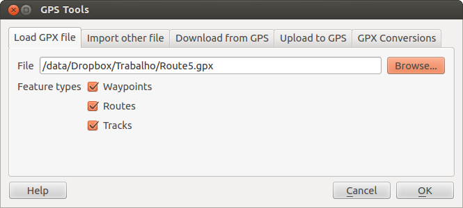
The GPS Tools dialog window 
Gebruik de knop [Bladeren...] om het GPX-bestand te selecteren, gebruik dan de keuzevakken om de typen objecten te selecteren die u wilt laden vanuit dat GPX-bestand. Elk type object zal in een afzonderlijke laag worden geladen als u op [OK] klikt. Het bestand national_monuments.gpx bevat alleen waypoints.
Notitie
GPS units allow you to store data in different coordinate systems. When downloading a GPX file (from your GPS unit or a web site) and then loading it in QGIS, be sure that the data stored in the GPX file uses WGS 84 (latitude/longitude). QGIS expects this, and it is the official GPX specification. See http://www.topografix.com/GPX/1/1/.
GPSBabel
Since QGIS uses GPX files, you need a way to convert other GPS file formats to GPX. This can be done for many formats using the free program GPSBabel, which is available at http://www.gpsbabel.org. This program can also transfer GPS data between your computer and a GPS device. QGIS uses GPSBabel to do these things, so it is recommended that you install it. However, if you just want to load GPS data from GPX files you will not need it. Version 1.2.3 of GPSBabel is known to work with QGIS, but you should be able to use later versions without any problems.
GPS-gegevens importeren
U gebruikt het gereedschap Ander bestand importeren in het dialoogvenster van GPS-gereedschap om GPS-gegevens te importeren vanuit een bestand dat geen GPX-bestand is. Hier selecteert u het bestand dat u wilt importeren (en het bestandstype), welk type object u er uit wilt importeren, waar u het geconverteerde GPX-bestand wilt opslaan en wat de naam van de nieuwe laag moet zijn. Onthoud dat niet alle indelingen voor GPS-gegevens alle drie de typen objecten ondersteunen, dus voor veel indelingen zult u slechts kunnen kiezen uit één of twee typen.
GPS-gegevens vanaf een apparaat downloaden
QGIS can use GPSBabel to download data from a GPS device directly as new vector layers. For this we use the Download from GPS tab of the GPS Tools dialog (see Figure_GPS_2). Here, we select the type of GPS device, the port that it is connected to (or USB if your GPS supports this), the feature type that you want to download, the GPX file where the data should be stored, and the name of the new layer.
Figure GPS 2:
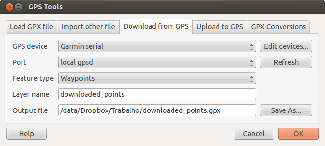
Het gereedschap om te downloaden
Het type apparaat dat u selecteert in het menu voor het GPS-apparaat bepaalt hoe GPSBabel probeert te communiceren met uw GPS-apparaat. Als geen van de beschikbare typen werkt met uw GPS-apparaat, kunt u een nieuw type definiëren (zie gedeelte Nieuwe typen apparaten definiëren).
De poort mag een bestandsnaam of een andere naam zijn die uw besturingssysteem gebruikt als een verwijzing naar de fysieke poort op uw computer waarmee het GPS-apparaat is verbonden. Het mag ook eenvoudigweg USB zijn, voor voor USB geschikte GPS-apparaten.
- Op Linux is het iets als /dev/ttyS0 of /dev/ttyS1.
 Op Windows is het COM1 of COM2.
When you click [OK], the data will be downloaded from the device and appear as a layer in QGIS.
GPS-gegevens uploaden naar een apparaat
You can also upload data directly from a vector layer in QGIS to a GPS device using the Upload to GPS tab of the GPS Tools dialog. To do this, you simply select the layer that you want to upload (which must be a GPX layer), your GPS device type, and the port (or USB) that it is connected to. Just as with the download tool, you can specify new device types if your device isn’t in the list.
This tool is very useful in combination with the vector-editing capabilities of QGIS. It allows you to load a map, create waypoints and routes, and then upload them and use them on your GPS device.
Nieuwe typen apparaten definiëren
There are lots of different types of GPS devices. The QGIS developers can’t test all of them, so if you have one that does not work with any of the device types listed in the Download from GPS and Upload to GPS tools, you can define your own device type for it. You do this by using the GPS device editor, which you start by clicking the [Edit devices] button in the download or the upload tab.
To define a new device, you simply click the [New device] button, enter a name, enter download and upload commands for your device, and click the [Update device] button. The name will be listed in the device menus in the upload and download windows – it can be any string. The download command is the command that is used to download data from the device to a GPX file. This will probably be a GPSBabel command, but you can use any other command line program that can create a GPX file. QGIS will replace the keywords %type, %in, and %out when it runs the command.
%type zal worden vervangen door -w als u waypoints download , -r als u routes download en -t als u tracks download. Dit zijn opties voor de opdrachtregel die GPSBabel vertellen welk type object moet worden gedownload.
%in will be replaced by the port name that you choose in the download window and %out will be replaced by the name you choose for the GPX file that the downloaded data should be stored in. So, if you create a device type with the download command gpsbabel %type -i garmin -o gpx %in %out (this is actually the download command for the predefined device type ‘Garmin serial’) and then use it to download waypoints from port /dev/ttyS0 to the file output.gpx, QGIS will replace the keywords and run the command gpsbabel -w -i garmin -o gpx /dev/ttyS0 output.gpx.
De opdracht voor uploaden is de opdracht die wordt gebruikt om gegevens naar het apparaat te uploaden. Dezelfde sleutelwoorden worden gebruikt, maar %in wordt nu vervangen door de naam van het GPX-bestand voor de laag die wordt geüpload, en %out wordt vervangen door de naam van de poort.
U kunt meer over GPSBabel en de daarvoor beschikbare opties voor de opdrachtregel te weten komen op http://www.gpsbabel.org.
Als u eenmaal een nieuw type apparaat heeft gemaakt, zal het worden vermeld in de lijsten met apparaten voor de gereedschappen Download en Upload.
Points/tracks downloaden vanaf GPS-apparaten
Zoals beschreven in eerdere gedeelten gebruikt QGIS GPSBabel om points/tracks direct in het project te downloaden. QGIS wordt standaard geleverd met een voorgedefinieerd profiel om vanaf apparaten van Garmin te downloaden. Helaas is er een probleem dat het niet mogelijk maakt om andere profielen aan te maken, dus is het direct in QGIS downloaden met behulp van GPS-gereedschap op dit moment beperkt tot USB-apparaten van Garmin.
Garmin GPSMAP 60cs
MS Windows
Installeer de Garmin USB-stuurprogramma’s vanaf http://www8.garmin.com/support/download_details.jsp?id=591
Verbind het apparaat. Open GPS-gereedschap en gebruik type=garmin serial en port=usb: Vul de velden Laagnaam en Uitvoerbestand. Soms lijkt het problemen te hebben met het opslaan naar een bepaalde map, het gebruiken van iets als c:\temp werkt gewoonlijk wel.
Ubuntu/Mint GNU/Linux
Het is eerst nodig om een probleem op te lossen voor de rechten van het apparaat, zoals beschreven op https://wiki.openstreetmap.org/wiki/USB_Garmin_on_GNU/Linux. U kunt proberen een bestand /etc/udev/rules.d/51-garmin.rules te maken dat deze regel bevat
ATTRS{idVendor}=="091e", ATTRS{idProduct}=="0003", MODE="666"
Daarna is het nodig u er van te overtuigen dat de kernelmodule garmin_gps niet is geladen
rmmod garmin_gps
en dan kunt u het GPS-gereedschap gebruiken. Helaas lijkt er een probleem te zijn en gewoonlijk bevriest QGIS enkele keren vóórdat de bewerking goed werkt.
BTGP-38KM gegevenslogger (alleen Bluetooth)
MS Windows
Het reeds vermelde probleem staat niet toe dat gegevens vanuit QGIS worden gedownload, dus is het nodig om GPSBabel vanaf de opdrachtregel te gebruiken of de interface ervan te gebruiken. De werkende opdracht is
gpsbabel -t -i skytraq,baud=9600,initbaud=9600 -f COM9 -o gpx -F C:/GPX/aaa.gpx
Ubuntu/Mint GNU/Linux
Gebruik dezelfde opdracht (of instellingen als u de GPSBabel GUI gebruikt) als in Windows. Op Linux kan het voorkomen dat u een bericht krijgt als
skytraq: Too many read errors on serial port
Het is slechts een kwestie van het uit- en opnieuw inschakelen van de gegevenslogger en opnieuw proberen.
BlueMax GPS-4044 gegevenslogger (zowel BT als USB)
MS Windows
Notitie
Het moet vóóraf zijn stuurprogramma’s installeren om het te kunnen gebruiken op Windows 7. Bekijk de site van de leverancier voor de juiste download.
Downloaden met GPSBabel, zowel met USB als met BT, geeft altijd een fout terug die lijkt op
gpsbabel -t -i mtk -f COM12 -o gpx -F C:/temp/test.gpx
mtk_logger: Can't create temporary file data.bin
Error running gpsbabel: Process exited unsucessfully with code 1
Ubuntu/Mint GNU/Linux
Met USB
Gebruik, nadat de kabel is verbonden, de opdracht dmesg om te zien welke poort zal worden gebruikt, bijvoorbeeld /dev/ttyACM3. Gebruik dan, zoals gewoonlijk, GPSBabel vanaf de opdrachtregel of met de GUI
gpsbabel -t -i mtk -f /dev/ttyACM3 -o gpx -F /home/user/bluemax.gpx
Met Bluetooth
Gebruik Blueman Device Manager om het apparaat te paren en het beschikbaar te maken via een systeempoort, voer dan GPSBabel uit
gpsbabel -t -i mtk -f /dev/rfcomm0 -o gpx -F /home/user/bluemax_bt.gpx