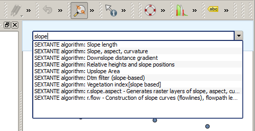
.
De QGIS commando’s
Processing bevat een praktisch gereedschap dat u in staat stelt algoritmen uit te voeren zonder de Toolbox te hoeven gebruiken, slechts door het intypen van de naam van het algoritme dat u wilt uitvoeren.
Dit gereedschap staat bekend als de QGIS Commando’s en het is slechts een eenvoudig tekstvak met automatisch aanvullen waar u de opdracht typt die u wilt uitvoeren.
The Commander is started from the Analysis menu or, more practically, by pressing Shift + Ctrl + M (you can change that default keyboard shortcut in the QGIS configuration if you prefer a different one). Apart from executing Processing algorithms, the Commander gives you access to most of the functionality in QGIS, which means that it gives you a practical and efficient way of running QGIS tasks and allows you to control QGIS with reduced usage of buttons and menus.
Moreover, the Commander is configurable, so you can add your custom commands and have them just a few keystrokes away, making it a powerful tool to help you become more productive in your daily work with QGIS.
Beschikbare opdrachten
De beschikbare opdrachten in Commando’s vallen in de volgende categorieën:
Processing algoritmen. Deze worden weergegeven als Processing algoritme: <naam van het algoritme>.
- Menu items. These are shown as Menu item: <menu entry text>. All menus items available from the QGIS interface are available, even if they are included in a submenu.
Functies voor Python. U kunt korte functies voor Python maken die dan zullen worden opgenomen in de lijst met beschikbare opdrachten. Zij worden weergegeven als Function: <naam van de functie>.
Begin, om een van de bovenstaande uit te voeren, eenvoudigweg te typen en selecteer dan het corresponderende element uit de lijst met beschikbare opdrachten die verschijnt na het filteren van de gehele lijst met opdrachten met de tekst die u heeft ingevoerd.
In the case of calling a Python function, you can select the entry in the list, which is prefixed by Function: (for instance, Function: removeall), or just directly type the function name (``removeall in the previous example). There is no need to add brackets after the function name.
Aangepaste functies maken
Custom functions are added by entering the corresponding Python code in the commands.py file that is found in the .qgis/sextante/commander directory in your user folder. It is just a simple Python file where you can add the functions that you need.
The file is created with a few example functions the first time you open the Commander. If you haven’t launched the Commander yet, you can create the file yourself. To edit the commands file, use your favorite text editor. You can also use a built-in editor by calling the edit command from the Commander. It will open the editor with the commands file, and you can edit it directly and then save your changes.
U kunt bijvoorbeeld de volgende functie toevoegen, die alle lagen verwijderd:
from qgis.gui import *

def removeall():
    mapreg = QgsMapLayerRegistry.instance()
    mapreg.removeAllMapLayers()
Wanneer u de functie eenmaal heeft toegevoegd zal die beschikbaar zijn in Commando’s, en u kunt hem uitvoeren door te typen removeall. Er is niets anders nodig dan het schrijven van de functie zelf.
Functies kunnen parameters opnemen. Voeg *args toe aan uw definitie van de functie om argumenten te kunnen opnemen. Bij het aanroepen van de functie vanuit Commando’s, moeten parameters worden doorgegeven door ze te scheiden door spaties.
Hier is een voorbeeld van een functie die een laag laadt en een parameter opneemt met de bestandsnaam van de te laden laag.
import processing

def load(*args):
  processing.load(args[0])
If you want to load the layer in /home/myuser/points.shp, type load /home/myuser/points.shp in the Commander text box.

