18.2.2. サービス
QGISサーバーでは、 Open Geospatial Consortium(OGC) に記載されているように、標準プロトコルに従ってデータを提供できます。
WMS 1.1.0 and 1.3.0
WFS 1.0.0 and 1.1.0
WFS3 (OGC API - Features)
WCS 1.1.1
WMTS 1.0.0
QGISレンダリングエンジンのおかげでその振る舞いをカスタマイズする可能性を大いに高めるオリジナルの規格に加えて、追加のベンダーパラメータと要求がサポートされています。
18.2.2.1. Web地図サービス (WMS)
QGISサーバーに実装された 1.1.0 および 1.3.0 WMS標準は、QGISプロジェクトから作成された地図または凡例の画像を要求するHTTPインターフェースを提供します。典型的なWMSリクエストは、使用するQGISプロジェクト、レンダリングするレイヤ、作成する画像フォーマットを定義します。 Styled Layer Descriptor(SLD) についても基本的なサポートが利用可能です。
Specifications:
Standard requests provided by QGIS Server:
Request |
説明 |
|---|---|
GetCapabilities |
Returns XML metadata with information about the server |
GetMap |
Returns a map |
GetFeatureInfo |
Retrieves data (geometry and values) for a pixel location |
GetLegendGraphics |
Returns legend symbols |
Vendor requests provided by QGIS Server:
Request |
説明 |
|---|---|
GetPrint |
Returns a QGIS composition |
GetProjectSettings |
Returns specific information about QGIS Server |
18.2.2.1.1. GetMap
Standard parameters for the GetMap request according to the OGC WMS 1.1.0 and 1.3.0 specifications:
パラメーター |
必須 |
説明 |
|---|---|---|
SERVICE |
はい |
Name of the service (WMS) |
VERSION |
いいえ |
Version of the service |
REQUEST |
はい |
Name of the request (GetMap) |
LAYERS |
いいえ |
Layers to display |
STYLES |
いいえ |
Layers' style |
SRS / CRS |
はい |
座標参照系 |
BBOX |
いいえ |
Map extent |
WIDTH |
はい |
Width of the image in pixels |
HEIGHT |
はい |
Height of the image in pixels |
FORMAT |
いいえ |
Image format |
TRANSPARENT |
いいえ |
透明な背景 |
SLD |
いいえ |
URL of an SLD to be used for styling |
SLD_BODY |
いいえ |
In-line SLD (XML) to be used for styling |
標準のものに加えて、QGISサーバーでは以下の追加パラメータをサポートしています:
パラメーター |
必須 |
説明 |
|---|---|---|
MAP |
はい |
Specify the QGIS project file |
BGCOLOR |
いいえ |
Specify the background color |
DPI |
いいえ |
Specify the output resolution |
IMAGE_QUALITY |
いいえ |
JPEG compression |
OPACITIES |
いいえ |
Opacity for layer or group |
FILTER |
いいえ |
Subset of features |
SELECTION |
いいえ |
Highlight features |
FILE_NAME |
いいえ |
Only for File name of the downloaded file |
FORMAT_OPTIONS |
いいえ |
Only for
|
TILED |
いいえ |
Working in tiled mode |
URL example:
http://localhost/qgis_server?
SERVICE=WMS
&VERSION=1.3.0
&REQUEST=GetMap
&MAP=/home/qgis/projects/world.qgs
&LAYERS=mylayer1,mylayer2,mylayer3
&STYLES=style1,default,style3
&OPACITIES=125,200,125
&CRS=EPSG:4326
&WIDTH=400
&HEIGHT=400
&FORMAT=image/png
&TRANSPARENT=TRUE
&DPI=300
&TILED=TRUE
18.2.2.1.1.1. SERVICE
This parameter has to be WMS in case of the GetMap request.
18.2.2.1.1.2. VERSION
This parameter allows to specify the version of the service to use.
Available values for the VERSION parameter are:
1.1.01.3.0
If no version is indicated in the request, then 1.3.0 is used by
default.
According to the version number, slight differences have to be expected as explained later for the next parameters:
CRS/SRSBBOX
18.2.2.1.1.3. REQUEST
This parameter is GetMap in case of the GetMap request.
18.2.2.1.1.4. LAYERS
This parameter allows to specify the layers to display on the map. Names have to be separated by a comma.
In addition, QGIS Server introduced some options to select layers by:
a short name
the layer id
The short name of a layer may be configured through in layer menu. If the short name is defined, then it's used by default instead of the layer's name:
http://localhost/qgisserver?
SERVICE=WMS
&REQUEST=GetMap
&LAYERS=mynickname1,mynickname2
&...
さらに、 ダイアログの メニューにIDでレイヤーを選択できるプロジェクトオプションがあります。このオプションを有効にするには、チェックボックス レイヤーIDを名前として使用 を選択する必要があります。
http://localhost/qgisserver?
SERVICE=WMS
&REQUEST=GetMap
&LAYERS=mylayerid1,mylayerid2
&...
18.2.2.1.1.5. STYLES
This parameter can be used to specify a layer's style for the
rendering step.
Styles have to be separated by a comma. The name of the default style
is default.
18.2.2.1.1.6. SRS / CRS
This parameter allows to indicate the map output Spatial Reference
System in WMS 1.1.0 and has to be formed like EPSG:XXXX.
Note that CRS is also supported if current version is 1.1.0.
For WMS 1.3.0, CRS parameter is preferable but SRS is also
supported.
Note that if both CRS and SRS parameters are indicated in the
request, then it's the current version indicated in VERSION
parameter which is decisive.
In the next case, the SRS parameter is kept whatever the
VERSION parameter because CRS is not indicated:
http://localhost/qgisserver?
SERVICE=WMS
&REQUEST=GetMap
&VERSION=1.3.0
&SRS=EPSG:2854
&...
In the next case, the SRS parameter is kept instead of CRS
because of the VERSION parameter:
http://localhost/qgisserver?
SERVICE=WMS
&REQUEST=GetMap
&VERSION=1.1.0
&CRS=EPSG:4326
&SRS=EPSG:2854
&...
In the next case, the CRS parameter is kept instead of SRS
because of the VERSION parameter:
http://localhost/qgisserver?
SERVICE=WMS
&REQUEST=GetMap
&VERSION=1.3.0
&CRS=EPSG:4326
&SRS=EPSG:2854
&...
18.2.2.1.1.7. BBOX
This parameter allows to specify the map extent with units according to the current CRS. Coordinates have to be separated by a comma.
However, a slight difference has to be noticed according to the
current VERSION parameter.
In WMS 1.1.0, coordinates are formed like
minx,miny,maxx,maxy or minlong,minlat,maxlong,maxlat.
For example:
http://localhost/qgisserver?
SERVICE=WMS
&REQUEST=GetMap
&VERSION=1.1.0
&SRS=epsg:4326
&BBOX=-180,-90,180,90
&...
But the axis is reversed in WMS 1.3.0, so coordinates are formed
like:
miny,minx,maxy,maxx or minlat,minlong,maxlat,maxlong.
For example:
http://localhost/qgisserver?
SERVICE=WMS
&REQUEST=GetMap
&VERSION=1.3.0
&CRS=epsg:4326
&BBOX=-90,-180,90,180
&...
18.2.2.1.1.8. WIDTH
This parameter allows to specify the width in pixels of the output image.
18.2.2.1.1.9. HEIGHT
This parameter allows to specify the height in pixels of the output image.
18.2.2.1.1.10. FORMAT
This parameter may be used to specify the format of map image. Available values are:
jpgjpegimage/jpegimage/pngimage/png; mode=1bitimage/png; mode=8bitimage/png; mode=16bitapplication/dxfOnly layers that have read access in the WFS service are exported in the DXF format.URL example:
http://localhost/qgisserver?
SERVICE=WMS&VERSION=1.3.0
&REQUEST=GetMap
&FORMAT=application/dxf
&LAYERS=Haltungen,Normschacht,Spezialbauwerke
&STYLES=
&CRS=EPSG%3A21781&BBOX=696136.28844801,245797.12108743,696318.91114315,245939.25832905
&WIDTH=1042
&HEIGHT=811
&FORMAT_OPTIONS=MODE:SYMBOLLAYERSYMBOLOGY;SCALE:250&FILE_NAME=plan.dxf
18.2.2.1.1.11. TRANSPARENT
This boolean parameter can be used to specify the background transparency. Available values are (not case sensitive):
TRUEFALSE
However, this parameter is ignored if the format of the map image
indicated with FORMAT is different from PNG.
18.2.2.1.1.12. MAP
This parameter allows to define the QGIS project file to use.
GetMap パラメータテーブル で述べたように、リクエストは実際に動作するためにQGISプロジェクトを必要とするので MAP は必須です。しかし、 QGIS_PROJECT_FILE 環境変数がデフォルトのQGISプロジェクトを定義するために使用されるかもしれません。この場合、 MAP はもはや必須のパラメータではありません。より詳しい情報は 高度な構成 を参照してください。
18.2.2.1.1.13. BGCOLOR
This parameter allows to indicate a background color for the map image.
However it cannot be combined with TRANSPARENT parameter in case of
PNG images (transparency takes priority). The colour may be literal or
in hexadecimal notation.
URL example with the literal notation:
http://localhost/qgisserver?
SERVICE=WMS
&REQUEST=GetMap
&VERSION=1.3.0
&BGCOLOR=green
&...
URL example with the hexadecimal notation:
http://localhost/qgisserver?
SERVICE=WMS
&REQUEST=GetMap
&VERSION=1.3.0
&BGCOLOR=0x00FF00
&...
18.2.2.1.1.14. DPI
This parameter can be used to specify the requested output resolution.
18.2.2.1.1.15. IMAGE_QUALITY
This parameter is only used for JPEG images. By default, the JPEG
compression is -1.
You can change the default per QGIS project in the
menu of the
dialog.
If you want to override it in a GetMap request you can do it using
the IMAGE_QUALITY parameter.
18.2.2.1.1.16. OPACITIES
Opacity can be set on layer or group level. Allowed values range from 0 (fully transparent) to 255 (fully opaque).
18.2.2.1.1.17. FILTER
A subset of layers can be selected with the FILTER parameter.
The syntax is basically the same as for the QGIS subset string.
However, there are some restrictions to avoid SQL injections into
databases via QGIS Server.
If a dangerous string is found in the parameter, QGIS Server will
return the next error:
Indeed, text strings need to be enclosed with quotes (single quotes
for strings, double quotes for attributes). A space between each
word / special character is mandatory. Allowed Keywords and special
characters are 'AND','OR','IN','=','<','>=','>','>=','!=*,'(',')'.
Semicolons in string expressions are not allowed.
URL example:
http://localhost/qgisserver?
SERVICE=WMS
&REQUEST=GetMap
&LAYERS=mylayer1,mylayer2,mylayer3
&FILTER=mylayer1:"col1";mylayer1,mylayer2:"col2" = 'blabla'
&...
In this example, the same filter (field col2 equals the string
blabla) is applied to layers mylayer1 and mylayer2, while
the filter on col1 is only applied to mylayer1.
注釈
It is possible to make attribute searches via GetFeatureInfo and omit the X/Y parameter if a FILTER is there. QGIS Server then returns info about the matching features and generates a combined bounding box in the XML output.
18.2.2.1.1.18. SELECTION
The SELECTION parameter can highlight features from one or more
layers.
Vector features can be selected by passing comma separated lists with
feature ids.
http://localhost/qgisserver?
SERVICE=WMS
&REQUEST=GetMap
&LAYERS=mylayer1,mylayer2
&SELECTION=mylayer1:3,6,9;mylayer2:1,5,6
&...
The following image presents the response from a GetMap request using
the SELECTION option e.g.
http://myserver.com/...&SELECTION=countries:171,65.
As those features id's correspond in the source dataset to France and Romania they're highlighted in yellow.

図 18.8 SELECTIONパラメーターを指定したGetMapリクエストに対するサーバーの応答
18.2.2.1.1.19. TILED
Set the TILED parameter to TRUE to tell QGIS Server to work in
tiled mode, and to apply the Tile buffer configured in the QGIS
project.
When TILED is TRUE and when a non-zero Tile buffer is
configured in the QGIS project, features outside the tile extent are
drawn to avoid cut symbols at tile boundaries.
TILED defaults to FALSE.
18.2.2.1.2. GetFeatureInfo
Standard parameters for the GetFeatureInfo request according to the OGC WMS 1.1.0 and 1.3.0 specifications:
パラメーター |
必須 |
説明 |
|---|---|---|
SERVICE |
はい |
Name of the service (WMS) |
VERSION |
いいえ |
|
REQUEST |
はい |
|
LAYERS |
いいえ |
|
STYLES |
いいえ |
|
SRS / CRS |
はい |
|
BBOX |
いいえ |
|
WIDTH |
はい |
|
HEIGHT |
はい |
|
TRANSPARENT |
いいえ |
|
INFO_FORMAT |
いいえ |
出力形式 |
QUERY_LAYERS |
はい |
Layers to query |
FEATURE_COUNT |
いいえ |
Maximum number of features to return |
I |
いいえ |
Pixel column of the point to query |
X |
いいえ |
Same as I parameter, but in WMS 1.1.0 |
J |
いいえ |
Pixel row of the point to query |
Y |
いいえ |
Same as J parameter, but in WMS 1.1.0 |
標準のものに加えて、QGISサーバーでは以下の追加パラメータをサポートしています:
パラメーター |
必須 |
説明 |
|---|---|---|
MAP |
はい |
|
FILTER |
いいえ |
|
FI_POINT_TOLERANCE |
いいえ |
Tolerance in pixels for point layers |
FI_LINE_TOLERANCE |
いいえ |
ラインレイヤでの許容誤差(ピクセル) |
FI_POLYGON_TOLERANCE: |
いいえ |
Tolerance in pixels for polygon layers |
FILTER_GEOM |
いいえ |
Geometry filtering |
WITH_MAPTIP |
いいえ |
Add map tips to the output |
WITH_GEOMETRY |
いいえ |
Add geometry to the output |
URL example:
http://localhost/qgisserver?
SERVICE=WMS
&VERSION=1.3.0
&REQUEST=GetMap
&MAP=/home/qgis/projects/world.qgs
&LAYERS=mylayer1,mylayer2,mylayer3
&CRS=EPSG:4326
&WIDTH=400
&HEIGHT=400
&INFO_FORMAT=text/xml
&TRANSPARENT=TRUE
&QUERY_LAYERS=mylayer1
&FEATURE_COUNT=3
&I=250
&J=250
18.2.2.1.2.1. INFO_FORMAT
このパラメータは結果のフォーマットを指定するために使用されます。利用可能な値は以下のとおりです:
text/xmltext/htmltext/plainapplication/vnd.ogc.gmlapplication/json
18.2.2.1.2.2. QUERY_LAYERS
This parameter specifies the layers to display on the map. Names are separated by a comma.
In addition, QGIS Server introduces options to select layers by:
short name
layer id
See the LAYERS parameter defined in
See GetMap for more information.
18.2.2.1.2.3. FEATURE_COUNT
このパラメータでは、レイヤごとに返す地物の最大数を指定します。例えば、 QUERY_LAYERS が layer1,layer2 に設定され、 FEATURE_COUNT が 3 に設定されている場合、layer1から最大3つの地物が返されます。同様に、layer2から最大3つの地物が返されます。
By default, only 1 feature per layer is returned.
18.2.2.1.2.4. I
This parameter, defined in WMS 1.3.0, allows you to specify the pixel column of the query point.
18.2.2.1.2.5. X
Same parameter as I, but defined in WMS 1.1.0.
18.2.2.1.2.6. J
This parameter, defined in WMS 1.3.0, allows you to specify the pixel row of the query point.
18.2.2.1.2.7. Y
Same parameter as J, but defined in WMS 1.1.0.
18.2.2.1.2.8. FI_POINT_TOLERANCE
このパラメータではラインレイヤでの許容誤差(ピクセル)を指定します。
18.2.2.1.2.9. FI_LINE_TOLERANCE
This parameter specifies the tolerance in pixels for line layers.
18.2.2.1.2.10. FI_POLYGON_TOLERANCE:
This parameter specifies the tolerance in pixels for polygon layers.
18.2.2.1.2.11. FILTER_GEOM
This parameter specifies a WKT geometry with which features have to intersect.
18.2.2.1.2.12. WITH_MAPTIP
This parameter specifies whether to add map tips to the output.
Available values are (not case sensitive):
TRUEFALSE
18.2.2.1.2.13. WITH_GEOMETRY
This parameter specifies whether to add geometries to the output. To use this feature you must first enable the Add geometry to feature response option in the QGIS project. See Configure your project.
Available values are (not case sensitive):
TRUEFALSE
18.2.2.1.3. GetPrint
QGISサーバには、PDFまたはピクセル形式のプリントレイアウト出力を作成する機能があります。公表されたプロジェクトでのプリントレイアウトがテンプレートとして使用されます。GETPRINT要求では、クライアントは含まれているレイアウト地図とラベルのパラメータを指定する可能性があります。
Parameters for the GetPrint request:
パラメーター |
必須 |
説明 |
|---|---|---|
MAP |
はい |
Specify the QGIS project file |
SERVICE |
はい |
Name of the service (WMS) |
VERSION |
いいえ |
|
REQUEST |
はい |
Name of the request (GetPrint) |
LAYERS |
いいえ |
|
TEMPLATE |
はい |
Layout template to use |
SRS / CRS |
はい |
|
FORMAT |
はい |
出力形式 |
ATLAS_PK |
いいえ |
Atlas features |
STYLES |
いいえ |
|
TRANSPARENT |
いいえ |
|
OPACITIES |
いいえ |
|
SELECTION |
いいえ |
|
mapX:EXTENT |
いいえ |
Extent of the map 'X' |
mapX:LAYERS |
いいえ |
Layers of the map 'X' |
mapX:STYLES |
いいえ |
Layers' style of the map 'X' |
mapX:SCALE |
いいえ |
Layers' scale of the map 'X' |
mapX:ROTATION |
いいえ |
Rotation of the map 'X' |
mapX:GRID_INTERVAL_X |
いいえ |
Grid interval on x axis of the map 'X' |
mapX:GRID_INTERVAL_Y |
いいえ |
Grid interval on y axis of the map 'X' |
URL example:
http://localhost/qgisserver?
SERVICE=WMS
&VERSION=1.3.0
&REQUEST=GetPrint
&MAP=/home/qgis/projects/world.qgs
&CRS=EPSG:4326
&FORMAT=png
&map0:EXTENT=-180,-90,180,90
&map0:LAYERS=mylayer1,mylayer2,mylayer3
&map0:OPACITIES=125,200,125
&map0:ROTATION=45
レイアウトテンプレートには複数のマップが含まれている可能性があることに注意してください。このように、特定のマップを設定したい場合は、 mapX: パラメータを使う必要があります。ここで、 X は GetProjectSettings リクエストのおかげで取得できる正数です。
For example:
<WMS_Capabilities>
...
<ComposerTemplates xsi:type="wms:_ExtendedCapabilities">
<ComposerTemplate width="297" height="210" name="Druckzusammenstellung 1">
<ComposerMap width="171" height="133" name="map0"/>
<ComposerMap width="49" height="46" name="map1"/></ComposerTemplate>
</ComposerTemplates>
...
</WMS_Capabilities>
18.2.2.1.3.1. SERVICE
This parameter has to be WMS.
18.2.2.1.3.2. REQUEST
This parameter has to be GetPrint for the GetPrint request.
18.2.2.1.3.3. TEMPLATE
This parameter can be used to specify the name of a layout template to use for printing.
18.2.2.1.3.4. FORMAT
This parameter specifies the format of map image. Available values are:
jpgjpegimage/jpegpngimage/pngsvgimage/svgimage/svg+xmlpdfapplication/pdf
If the FORMAT parameter is different from one of these values,
then an exception is returned.
18.2.2.1.3.5. ATLAS_PK
This parameter allows activation of Atlas rendering by indicating
which features we want to print.
In order to retrieve an atlas with all features, the * symbol may
be used (according to the maximum number of features allowed in the
project configuration).
When FORMAT is pdf, a single PDF document combining the feature
pages is returned.
For all other formats, a single page is returned.
18.2.2.1.3.6. mapX:EXTENT
This parameter specifies the extent for a layout map item as xmin,ymin,xmax,ymax.
18.2.2.1.3.7. mapX:ROTATION
This parameter specifies the map rotation in degrees.
18.2.2.1.3.8. mapX:GRID_INTERVAL_X
This parameter specifies the grid line density in the X direction.
18.2.2.1.3.9. mapX:GRID_INTERVAL_Y
This parameter specifies the grid line density in the Y direction.
18.2.2.1.3.10. mapX:SCALE
このパラメータは、レイアウト地図アイテムの地図縮尺を指定します。これは、クライアントとサーバーで縮尺分母を計算するアルゴリズムが異なる場合でもレイヤとラベルの縮尺に基づく可視性を確保するのに役立ちます。
18.2.2.1.3.11. mapX:LAYERS
This parameter specifies the layers for a layout map item. See See GetMap for more information on this parameter.
18.2.2.1.3.12. mapX:STYLES
This parameter specifies the layers' styles defined in a specific layout map item. See See GetMap for more information on this parameter.
18.2.2.1.4. GetLegendGraphics
いくつかの追加のパラメーターは、凡例の要素のサイズを変更できます:
BOXSPACE 凡例フレームと内容の間の空白(mm)
LAYERSPACE vertical space between layers (mm)
LAYERTITLESPACE レイヤータイトルと後続アイテム間の垂直方向のスペース(mm)
SYMBOLSPACE シンボルとアイテム間の垂直方向の間隔(mm)
ICONLABELSPACE シンボルとラベルのテキストの間の水平スペース(ミリメートル)
SYMBOLWIDTH シンボルプレビューの幅(mm)
SYMBOLHEIGHT シンボルプレビューの高さ(mm)
これらのパラメーターは、レイヤーのタイトルや項目ラベルのフォントプロパティを変更します。
LAYERFONTFAMILY / ITEMFONTFAMILY レイヤータイトル/項目テキストのためのフォントファミリー
LAYERFONTBOLD / ITEMFONTBOLD
TRUEto use a bold fontLAYERFONTSIZE / ITEMFONTSIZE ポイントでのフォントサイズ
LAYERFONTITALIC / ITEMFONTITALIC
TRUEto use italic fontLAYERFONTCOLOR / ITEMFONTCOLOR Hex color code (e.g.
#FF0000for red)LAYERTITLE
FALSEto get only the legend graphics without the layer titleRULELABEL:
FALSElegend graphics without item labelsAUTOhide item label for layers with Single symbol rendering
コンテストに基づく凡例。これらのパラメータでは、要求された領域に入る地物のシンボルだけを表示する凡例をクライアントに要求させます。
BBOX 凡例を構築する必要のある地域
CRS / SRS BBOX座標を定義するために採用された座標参照系
設定されている場合** WIDTH / HEIGHT **これらは、地図ビューの画像サイズに応じてQGIS サーバーがシンボルを縮尺設定できるように、GetMapリクエストのために定義されたものと一致する必要があります。
Content based legend features are based on the UMN MapServer implementation:
SHOWFEATURECOUNT if set to
TRUEadds in the legend the feature count of the features like in the following image:
18.2.2.1.5. GetProjectSettings
このリクエストタイプは GetCapabilities に似ていますが、それはQGIS サーバーに対してより具体的であり、クライアントは、GetCapabilities出力では利用できない追加情報を読み取ることができます:
レイヤーの初期可視性
ベクターの属性とその編集タイプに関する情報
レイヤーの順序と描画順序に関する情報
WFSに掲載されたレイヤのリスト
18.2.2.2. Web Feature Service (WFS)
The 1.0.0 and 1.1.0 WFS standards implemented in QGIS Server provide a HTTP interface to query geographic features from a QGIS project. A typical WFS request defines the QGIS project to use and the layer to query.
Specifications document according to the version number of the service:
Standard requests provided by QGIS Server:
Request |
説明 |
|---|---|
GetCapabilities |
Returns XML metadata with information about the server |
GetFeature |
Returns a selection of features |
DescribeFeatureType |
Returns a description of feature types and properties |
Transaction |
Allows features to be inserted, updated or deleted |
18.2.2.2.1. GetFeature
Standard parameters for the GetFeature request according to the OGC WFS 1.0.0 and 1.1.0 specifications:
パラメーター |
必須 |
説明 |
|---|---|---|
SERVICE |
はい |
Name of the service |
VERSION |
いいえ |
Version of the service |
REQUEST |
はい |
Name of the request |
TYPENAME |
いいえ |
レイヤの名前 |
OUTPUTFORMAT |
いいえ |
Output Format |
RESULTTYPE |
いいえ |
Type of the result |
PROPERTYNAME |
いいえ |
Name of properties to return |
MAXFEATURES |
いいえ |
Maximum number of features to return |
SRSNAME |
いいえ |
座標参照系 |
FEATUREID |
いいえ |
Filter the features by ids |
FILTER |
いいえ |
OGC Filter Encoding |
BBOX |
いいえ |
Map Extent |
SORTBY |
いいえ |
Sort the results |
標準のものに加えて、QGISサーバーでは以下の追加パラメータをサポートしています:
パラメーター |
必須 |
説明 |
|---|---|---|
MAP |
はい |
Specify the QGIS project file |
STARTINDEX |
いいえ |
Paging |
GEOMETRYNAME |
いいえ |
Type of geometry to return |
EXP_FILTER |
いいえ |
Expression filtering |
18.2.2.2.1.1. SERVICE
This parameter has to be WFS in case of the GetFeature
request.
For example:
http://localhost/qgisserver?
SERVICE=WFS
&...
18.2.2.2.1.2. VERSION
This parameter allows to specify the version of the service to use.
Available values for the VERSION parameter are:
1.0.01.1.0
If no version is indicated in the request, then 1.1.0 is used by
default.
URL example:
http://localhost/qgisserver?
SERVICE=WFS
&VERSION=1.1.0
&...
18.2.2.2.1.3. REQUEST
This parameter is GetFeature in case of the GetFeature
request.
URL example:
http://localhost/qgisserver?
SERVICE=WFS
&VERSION=1.1.0
&REQUEST=GetFeature
&...
18.2.2.2.1.4. RESULTTYPE
This parameter may be used to specify the kind of result to return. Available values are:
results: the default behaviorhits: returns only a feature count
URL example:
http://localhost/qgisserver?
SERVICE=WFS
&VERSION=1.1.0
&REQUEST=GetFeature
&RESULTTYPE=hits
&...
18.2.2.2.1.5. GEOMETRYNAME
このパラメータは、地物に返すジオメトリの種類を指定するために使用できます。利用可能な値は以下のとおりです:
範囲重心なし
URL example:
http://localhost/qgisserver?
SERVICE=WFS
&VERSION=1.1.0
&REQUEST=GetFeature
&GEOMETRYNAME=centroid
&...
18.2.2.2.1.6. STARTINDEX
This parameter is standard in WFS 2.0, but it's an extension for WFS
1.0.0.
Actually, it can be used to skip some features in the result set and
in combination with MAXFEATURES, it provides the ability to page
through results.
URL example:
http://localhost/qgisserver?
SERVICE=WFS
&VERSION=1.1.0
&REQUEST=GetFeature
&STARTINDEX=2
&...
18.2.2.3. Web Map Tile Service (WMTS)
QGISサーバに実装された 1.0.0 WMTS標準は、QGISプロジェクトから作成されたタイル地図画像を要求するためのHTTPインターフェースを提供します。典型的なWMTSリクエストでは、使用するQGISプロジェクト、レンダリングするレイヤなどの一部のWMSパラメータ、およびタイルパラメータを定義しました。
Specifications document of the service:
Standard requests provided by QGIS Server:
Request |
説明 |
|---|---|
GetCapabilities |
Returns XML metadata with information about the server |
GetTile |
Returns a tile |
GetFeatureInfo |
Retrieves data (geometry and values) for a pixel location |
18.2.2.3.1. GetCapabilities
Standard parameters for the GetCapabilities request according to the OGC WMTS 1.0.0 specifications:
パラメーター |
必須 |
説明 |
|---|---|---|
SERVICE |
はい |
Name of the service (WMTS) |
REQUEST |
はい |
Name of the request (GetCapabilities) |
標準のものに加えて、QGISサーバーでは以下の追加パラメータをサポートしています:
パラメーター |
必須 |
説明 |
|---|---|---|
MAP |
はい |
Specify the QGIS project file |
URL example:
http://localhost/qgisserver?
SERVICE=WMTS
&REQUEST=GetCapabilities
&MAP=/home/qgis/projects/world.qgs
18.2.2.3.1.1. SERVICE
This parameter has to be WMTS in case of the GetCapabilities
request.
18.2.2.3.1.2. REQUEST
This parameter is GetCapabilities in case of the
GetCapabilities request.
18.2.2.3.1.3. MAP
This parameter allows to define the QGIS project file to use.
18.2.2.3.2. GetTile
Standard parameters for the GetTile request according to the OGC WMTS 1.0.0 specifications:
パラメーター |
必須 |
説明 |
|---|---|---|
SERVICE |
はい |
Name of the service (WMTS) |
REQUEST |
はい |
Name of the request (GetTile) |
LAYER |
はい |
Layer identifier |
FORMAT |
はい |
Output format of the tile |
TILEMATRIXSET |
はい |
Name of the pyramid |
TILEMATRIX |
はい |
Meshing |
TILEROW |
はい |
Row coordinate in the mesh |
TILECOL |
はい |
Column coordinate in the mesh |
標準のものに加えて、QGISサーバーでは以下の追加パラメータをサポートしています:
パラメーター |
必須 |
説明 |
|---|---|---|
MAP |
はい |
Specify the QGIS project file |
URL example:
http://localhost/qgisserver?
SERVICE=WMTS
&REQUEST=GetTile
&MAP=/home/qgis/projects/world.qgs
&LAYER=mylayer
&FORMAT=image/png
&TILEMATRIXSET=EPSG:4326
&TILEROW=0
&TILECOL=0
18.2.2.3.2.1. SERVICE
This parameter has to be WMTS in case of the GetTile request.
18.2.2.3.2.2. REQUEST
This parameter is GetTile in case of the GetTile request.
18.2.2.3.2.3. LAYER
This parameter allows to specify the layer to display on the tile.
In addition, QGIS Server introduced some options to select a layer by:
a short name
the layer id
The short name of a layer may be configured through in layer menu. If the short name is defined, then it's used by default instead of the layer's name:
http://localhost/qgisserver?
SERVICE=WMTS
&REQUEST=GetTile
&LAYER=mynickname
&...
Moreover, there's a project option allowing to select layers by their id in menu of the dialog. To activate this option, the checkbox Use layer ids as names has to be selected.
http://localhost/qgisserver?
SERVICE=WMTS
&REQUEST=GetTile
&LAYER=mylayerid1
&...
18.2.2.3.2.4. FORMAT
This parameter may be used to specify the format of tile image. Available values are:
jpgjpegimage/jpegimage/png
If the FORMAT parameter is different from one of these values, then
the default format PNG is used instead.
18.2.2.3.2.5. TILEMATRIXSET
This parameter defines the CRS to use when computing the underlying
pyramid. Format: EPSG:XXXX.
18.2.2.3.2.6. TILEMATRIX
This parameter allows to define the matrix to use for the output tile.
18.2.2.3.2.7. TILEROW
This parameter allows to select the row of the tile to get within the matrix.
18.2.2.3.2.8. TILECOL
This parameter allows to select the column of the tile to get within the matrix.
18.2.2.3.2.9. MAP
This parameter allows to define the QGIS project file to use.
GetMap パラメータテーブル で述べたように、リクエストは実際に動作するためにQGISプロジェクトを必要とするので MAP は必須です。しかし、 QGIS_PROJECT_FILE 環境変数がデフォルトのQGISプロジェクトを定義するために使用されるかもしれません。この場合、 MAP はもはや必須のパラメータではありません。より詳しい情報は 高度な構成 を参照してください。
18.2.2.3.3. GetFeatureInfo
Standard parameters for the GetFeatureInfo request according to the OGC WMTS 1.0.0 specifications:
パラメーター |
必須 |
説明 |
|---|---|---|
SERVICE |
はい |
Name of the service (WMTS) |
REQUEST |
はい |
Name of the request (GetFeatureInfo) |
LAYER |
はい |
Layer identifier |
INFOFORMAT |
いいえ |
出力形式 |
I |
いいえ |
X coordinate of a pixel |
J |
いいえ |
Y coordinate of a pixel |
TILEMATRIXSET |
はい |
|
TILEMATRIX |
はい |
|
TILEROW |
はい |
|
TILECOL |
はい |
標準のものに加えて、QGISサーバーでは以下の追加パラメータをサポートしています:
パラメーター |
必須 |
説明 |
|---|---|---|
MAP |
はい |
Specify the QGIS project file |
URL example:
http://localhost/qgisserver?
SERVICE=WMTS
&REQUEST=GetFeatureInfo
&MAP=/home/qgis/projects/world.qgs
&LAYER=mylayer
&INFOFORMAT=image/html
&I=10
&J=5
18.2.2.3.3.1. SERVICE
This parameter has to be WMTS in case of the GetFeatureInfo
request.
18.2.2.3.3.2. REQUEST
This parameter is GetFeatureInfo in case of the
GetFeatureInfo request.
18.2.2.3.3.3. MAP
This parameter allows to define the QGIS project file to use.
GetMap パラメータテーブル で述べたように、リクエストは実際に動作するためにQGISプロジェクトを必要とするので MAP は必須です。しかし、 QGIS_PROJECT_FILE 環境変数がデフォルトのQGISプロジェクトを定義するために使用されるかもしれません。この場合、 MAP はもはや必須のパラメータではありません。より詳しい情報は 高度な構成 を参照してください。
18.2.2.3.3.4. LAYER
This parameter allows to specify the layer to display on the tile.
In addition, QGIS Server introduced some options to select a layer by:
a short name
the layer id
The short name of a layer may be configured through in layer menu. If the short name is defined, then it's used by default instead of the layer's name:
http://localhost/qgisserver?
SERVICE=WMTS
&REQUEST=GetFeatureInfo
&LAYER=mynickname
&...
Moreover, there's a project option allowing to select layers by their id in menu of the dialog. To activate this option, the checkbox Use layer ids as names has to be selected.
http://localhost/qgisserver?
SERVICE=WMTS
&REQUEST=GetFeatureInfo
&LAYER=mylayerid1
&...
18.2.2.3.3.5. INFOFORMAT
This parameter allows to define the output format of the result. Available values are:
text/xmltext/htmltext/plainapplication/vnd.ogc.gml
The default value is text/plain.
18.2.2.3.3.6. I
This parameter allows to define the X coordinate of the pixel for which we want to retrieve underlying information.
18.2.2.3.3.7. J
This parameter allows to define the Y coordinate of the pixel for which we want to retrieve underlying information.
18.2.2.4. WFS3 (OGC API Features)
WFS3 is the first implementation of the new generation of OGC protocols. It is described by the OGC API - Features - Part 1: Core document.
Here is a quick informal summary of the most important differences between the well known WFS protocol and WFS3:
WFS3 is based on a REST API
WFS3 API must follow the OPENAPI specifications
WFS3 supports multiple output formats but it does not dictate any (only GeoJSON and HTML are currently available in QGIS WFS3) and it uses content negotiation to determine which format is to be served to the client
JSON and HTML are first class citizens in WFS3
WFS3 is self-documenting (through the
/apiendpoint)WFS3 is fully navigable (through links) and browsable
重要
While the WFS3 implementation in QGIS can make use of the MAP
parameter to specify the project file, no extra query parameters
are allowed by the OPENAPI specification.
For this reason it is strongly recommended that MAP is not
exposed in the URL and the project file is specified in the
environment by other means (i.e. setting QGIS_PROJECT_FILE
in the environment through a web server rewrite rule).
注釈
The API endpoint provides comprehensive documentation of all supported parameters and output formats of your service. The following paragraphs will only describe the most important ones.
18.2.2.4.1. Resource representation
The QGIS Server WFS3 implementation currently supports the following resource representation (output) formats:
HTML
JSON
The format that is actually served will depend on content negotiation, but a specific format can be explicitly requested by appending a format specifier to the endpoints.
Supported format specifier extensions are:
.json.html
Additional format specifier aliases may be defined by specific endpoints:
.openapi: alias for.jsonsupported by the API endpoint.geojson: alias for.jsonsupported by the Features and Feature endpoints
18.2.2.4.2. Endpoints
The API provides a list of endpoints that the clients can retrieve. The system is designed in such a way that every response provides a set of links to navigate through all the provided resources.
Endpoints points provided by the QGIS implementation are:
名前 |
Path |
説明 |
|---|---|---|
Landing Page |
|
General information about the service and provides links to all available endpoints |
Conformance |
|
Information about the conformance of the service to the standards |
API |
|
Full description of the endpoints provided by the service and the returned documents structure |
Collections |
|
List of all collections (i.e. 'vector layers') provided by the service |
Collection |
|
Information about a collection (name, metadata, extent etc.) |
機能 |
|
List of the features provided by the collection |
Feature |
|
Information about a single feature |
18.2.2.4.2.1. Landing Page
The main endpoint is the Landing Page. From that page it is possible to navigate to all the available service endpoints. The Landing Page must provide links to
the API definition (path
/apilink relationsservice-descandservice-doc),the Conformance declaration (path
/conformance, link relationconformance), andthe Collections (path
/collections, link relationdata).

図 18.9 Server WFS3 landing page
18.2.2.4.2.2. API Definition
The API Definition is an OPENAPI-compliant description of the
API provided by the service.
In its HTML representation it is a browsable page where all the
endpoints and their response formats are accurately listed and
documented.
The path of this endpoint is /api.
The API definition provides a comprehensive and authoritative documentation of the service, including all supported parameters and returned formats.
注釈
This endpoint is analogue to WFS's GetCapabilities
18.2.2.4.2.3. Collections list
The collections endpoint provides a list of all the collections
available in the service.
Since the service "serves" a single QGIS project the collections are
the vector layers from the current project (if they were published as
WFS in the project properties).
The path of this endpoint is /collections/.

図 18.10 Server WFS3 collections list page
18.2.2.4.2.4. Collection detail
While the collections endpoint does not provide detailed information
about each available collection, that information is available in the
/collections/{collectionId} endpoints.
Typical information includes the extent, a description, CRSs and other
metadata.
The HTML representation also provides a browsable map with the available features.

図 18.11 Server WFS3 collection detail page
18.2.2.4.2.5. Features list
This endpoint provides a list of all features in a collection knowing
the collection ID.
The path of this endpoint is /collections/{collectionId}/items.
The HTML representation also provides a browsable map with the available features.
注釈
This endpoint is analogue to GetFeature in WFS 1 and WFS 2.

図 18.12 Server WFS3 features list page
18.2.2.4.2.6. Feature detail
This endpoint provides all the available information about a
single feature, including the feature attributes and its geometry.
The path of this endpoint is
/collections/{collectionId}/items/{itemId}.
The HTML representation also provides a browsable map with the feature geometry.
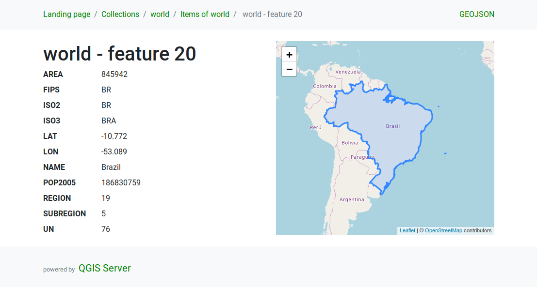
図 18.13 Server WFS3 feature detail page
18.2.2.4.3. Pagination
Pagination of a long list of features is implemented in the OGC API
through next and prev links, QGIS server constructs these
links by appending limit and offset as query string
parameters.
URL example:
http://localhost/qgisserver/wfs3/collection_one/items.json?offset=10&limit=10
注釈
The maximum acceptable value for limit can be configured with
the QGIS_SERVER_API_WFS3_MAX_LIMIT server configuration setting
(see: 環境変数).
18.2.2.4.4. 地物フィルタリング
The features available in a collection can be filtered/searched by specifying one or more filters.
18.2.2.4.4.1. Date and time filter
Collections with date and/or datetime attributes can be filtered by
specifying a datetime argument in the query string.
By default the first date/datetime field is used for filtering.
This behavior can be configured by setting a "Date" or "Time"
dimension in the section of
the layer properties dialog.
The date and time filtering syntax is fully described in the API Definition and also supports ranges (begin and end values are included) in addition to single values.
URL examples:
Returns only the features with date dimension matching 2019-01-01
http://localhost/qgisserver/wfs3/collection_one/items.json?datetime=2019-01-01
Returns only the features with datetime dimension matching
2019-01-01T01:01:01
http://localhost/qgisserver/wfs3/collection_one/items.json?datetime=2019-01-01T01:01:01
Returns only the features with datetime dimension in the range
2019-01-01T01:01:01 - 2019-01-01T12:00:00
http://localhost/qgisserver/wfs3/collection_one/items.json?datetime=2019-01-01T01:01:01/2019-01-01T12:00:00
18.2.2.4.4.2. Bounding box filter
A bounding box spatial filter can be specified with the bbox parameter:
The order of the comma separated elements is:
Lower left corner, WGS 84 longitude
Lower left corner, WGS 84 latitude
Upper right corner, WGS 84 longitude
Upper right corner, WGS 84 latitude
注釈
The OGC specifications also allow a 6 item bbox specifier where the third and sixth items are the Z components, this is not yet supported by QGIS server.
URL example:
http://localhost/qgisserver/wfs3/collection_one/items.json?bbox=-180,-90,180,90
If the CRS of the bounding box is not WGS84
(http://www.opengis.net/def/crs/OGC/1.3/CRS84), a different CRS can
be specified by using the optional parameter bbox-crs.
The CRS format identifier must be in the
OGC URI format:
URL example:
http://localhost/qgisserver/wfs3/collection_one/items.json?bbox=913191,5606014,913234,5606029&bbox-crs=http://www.opengis.net/def/crs/EPSG/9.6.2/3857
18.2.2.4.4.3. Attribute filters
Attribute filters can be combined with the bounding box filter and they
are in the general form: <attribute name>=<attribute value>.
Multiple filters can be combined using the AND operator.
URL example:
filters all features where attribute name equals "my value"
http://localhost/qgisserver/wfs3/collection_one/items.json?attribute_one=my%20value
Partial matches are also supported by using a * ("star") operator:
URL example:
filters all features where attribute name ends with "value"
http://localhost/qgisserver/wfs3/collection_one/items.json?attribute_one=*value
18.2.2.4.5. Attribute selection
The feature attributes returned by a Features list
call can be limited by adding a comma separated list of attribute names
in the optional properties query string argument.
URL example:
returns only the name attribute
http://localhost/qgisserver/wfs3/collection_one/items.json?properties=name
18.2.2.4.6. The HTML template language
The HTML representation uses a set of HTML templates to generate the
response.
The template is parsed by a template engine called
inja.
The templates can be customized by overriding them
(see: Template overrides).
The template has access to the same data that are available to the
JSON representation and a few additional functions are available to
the template:
18.2.2.4.6.1. Custom template functions
path_append( path ): appends a directory path to the current urlpath_chomp( n ): removes the specified number "n" of directory components from the current url pathjson_dump( ): prints the JSON data passed to the templatestatic( path ): returns the full URL to the specified static path. For example: "static( "/style/black.css" )" with a root path "http://localhost/qgisserver/wfs3" will return "http://localhost/qgisserver/wfs3/static/style/black.css".links_filter( links, key, value ): Returns filtered links from a link listcontent_type_name( content_type ): Returns a short name from a content type, for example "text/html" will return "HTML"
18.2.2.4.6.2. Template overrides
Templates and static assets are stored in subdirectories of the QGIS
server default API resource directory
(/usr/share/qgis/resources/server/api/ on a Linux system), the
base directory can be customized by changing the environment variable
QGIS_SERVER_API_RESOURCES_DIRECTORY.
A typical Linux installation will have the following directory tree:
/usr/share/qgis/resources/server/api/
└── ogc
    ├── schema.json
    ├── static
    │   ├── jsonFormatter.min.css
    │   ├── jsonFormatter.min.js
    │   └── style.css
    └── templates
        └── wfs3
            ├── describeCollection.html
            ├── describeCollections.html
            ├── footer.html
            ├── getApiDescription.html
            ├── getFeature.html
            ├── getFeatures.html
            ├── getLandingPage.html
            ├── getRequirementClasses.html
            ├── header.html
            ├── leaflet_map.html
            └── links.html
To override the templates you can copy the whole tree to another location
and point QGIS_SERVER_API_RESOURCES_DIRECTORY to the new location.
18.2.2.5. すべてのリクエストタイプでサポートされている追加パラメーター
The following extra parameters are supported by all protocols.
FILE_NAME: if set, the server response will be sent to the client as a file attachment with the specified file name.
注釈
Not available for WFS3.
MAP: Similar to MapServer, the
MAPparameter can be used to specify the path to the QGIS project file. You can specify an absolute path or a path relative to the location of the server executable (qgis_mapserv.fcgi). If not specified, QGIS Server searches for .qgs files in the directory where the server executable is located.例:
http://localhost/cgi-bin/qgis_mapserv.fcgi?\
  REQUEST=GetMap&MAP=/home/qgis/projects/world.qgs&...
注釈
QGISプロジェクトファイルをどこで検索するかをサーバーの実行可能ファイルに伝えるために、環境変数として QGIS_PROJECT_FILE を定義できます。この変数はQGISによってプロジェクトファイルが探される場所になります。定義されていない場合はリクエスト中のMAPパラメーターを使用し、最終的にはサーバーの実行可能ファイルのディレクトリを見ていきます。
18.2.2.6. REDLINING
この機能は利用可能であり、 GetMap および GetPrint 要求と共に使用できます。
赤線引き地物は、リクエスト中のジオメトリとラベルに渡すのに使用できます、標準返された画像(地図)上でサーバーによって重ねあわされます。これにより、ユーザーは、標準地図にないいくつかの領域、場所などに強調(emphasis)またはコメント(ラベル)を追加することが可能になります。
要求は以下の形式で行われます。
http://qgisplatform.demo/cgi-bin/qgis_mapserv.fcgi?map=/world.qgs&SERVICE=WMS&VERSION=1.3.0&
REQUEST=GetMap
...
&HIGHLIGHT_GEOM=POLYGON((590000 5647000, 590000 6110620, 2500000 6110620, 2500000 5647000, 590000 5647000))
&HIGHLIGHT_SYMBOL=<StyledLayerDescriptor><UserStyle><Name>Highlight</Name><FeatureTypeStyle><Rule><Name>Symbol</Name><LineSymbolizer><Stroke><SvgParameter name="stroke">%23ea1173</SvgParameter><SvgParameter name="stroke-opacity">1</SvgParameter><SvgParameter name="stroke-width">1.6</SvgParameter></Stroke></LineSymbolizer></Rule></FeatureTypeStyle></UserStyle></StyledLayerDescriptor>
&HIGHLIGHT_LABELSTRING=Write label here
&HIGHLIGHT_LABELSIZE=16
&HIGHLIGHT_LABELCOLOR=%23000000
&HIGHLIGHT_LABELBUFFERCOLOR=%23FFFFFF
&HIGHLIGHT_LABELBUFFERSIZE=1.5
ポリゴンとラベルが通常地図の上に描かれている、上記の要求によって出力された画像は次のとおりです:

図 18.14 レッドラインパラメーターを持つGetMapリクエストに対するサーバーの応答
このリクエストにはいくつかのパラメーターがあります。
HIGHLIGHT_GEOM: You can add POINT, MULTILINESTRING, POLYGON etc. It supports multipart geometries. Here is an example:
HIGHLIGHT_GEOM=MULTILINESTRING((0 0, 0 1, 1 1)). The coordinates should be in the CRS of the GetMap/GetPrint request.HIGHLIGHT_SYMBOL :ジオメトリの輪郭をどのように表示するかを制御し、ストロークの幅、色、不透明度を変更できます。
HIGHLIGHT_LABELSTRING :ラベルのテキストをこのパラメーターに渡すことができます。
HIGHLIGHT_LABELSIZE: このパラメーターは、ラベルのサイズを制御します。
HIGHLIGHT_LABELCOLOR: このパラメーターは、ラベルの色を制御します。
HIGHLIGHT_LABELBUFFERCOLOR: このパラメーターは、ラベルバッファの色を制御します。
HIGHLIGHT_LABELBUFFERSIZE: このパラメーターは、ラベルバッファのサイズを制御します。
18.2.2.7. External WMS layers
QGISサーバは、WMS GetMapとWMS GetPrintリクエストに外部WMSサーバからのレイヤを含めることを可能にします。これは、WebクライアントがWeb地図で外部の背景レイヤを使用している場合に特に便利です。パフォーマンス上の理由から、このようなレイヤはWebクライアントから直接要求される必要があります(QGISサーバを介してカスケードされることはありません)。ただし、印刷する場合は、印刷された地図に表示されるように、これらのレイヤーをQGISサーバ経由でカスケードする必要があります。
External layers can be added to the LAYERS parameter as EXTERNAL_WMS:<layername>. The parameters for the external WMS layers (e.g. url, format, dpiMode, crs, layers, styles) can later be given as service parameters <layername>:<parameter>. In a GetMap request, this might look like this:
http://localhost/qgisserver?
SERVICE=WMS&REQUEST=GetMap
...
&LAYERS=EXTERNAL_WMS:basemap,layer1,layer2
&STYLES=,,
&basemap:url=http://externalserver.com/wms.fcgi
&basemap:format=image/jpeg
&basemap:dpiMode=7
&basemap:crs=EPSG:2056
&basemap:layers=orthofoto
&basemap:styles=default
Similarly, external layers can be used in GetPrint requests:
http://localhost/qgisserver?
SERVICE=WMS
...
&REQUEST=GetPrint&TEMPLATE=A4
&map0:layers=EXTERNAL_WMS:basemap,layer1,layer2
&map0:EXTENT=<minx,miny,maxx,maxy>
&basemap:url=http://externalserver.com/wms.fcgi
&basemap:format=image/jpeg
&basemap:dpiMode=7
&basemap:crs=EPSG:2056
&basemap:layers=orthofoto
&basemap:styles=default