.
Suivi GPS en direct
To activate live GPS tracking in QGIS, you need to select Settings ‣ Panels
 GPS information. You will get a new docked window on the
left side of the canvas.
GPS information. You will get a new docked window on the
left side of the canvas.
Cette fenêtre propose quatre écrans différents :
 GPS position coordinates and an interface for manually entering
vertices and features
GPS position coordinates and an interface for manually entering
vertices and features GPS signal strength of satellite connections
 GPS polar screen showing number and polar position of
satellites
GPS polar screen showing number and polar position of
satellites GPS options screen (see figure_gps_options)
With a plugged-in GPS receiver (has to be supported by your operating system), a simple click on [Connect] connects the GPS to QGIS. A second click (now on [Disconnect]) disconnects the GPS receiver from your computer. For GNU/Linux, gpsd support is integrated to support connection to most GPS receivers. Therefore, you first have to configure gpsd properly to connect QGIS to it.
Warning
Si vous désirez enregistrer votre position sur la carte, vous devez au préalable, créer une nouvelle couche et la passer en mode édition.
Coordonnées de la position
If the GPS is receiving signals from satellites, you will
see your position in latitude, longitude and altitude together with additional
attributes.
Figure GPS Position:
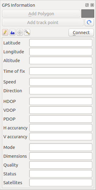
GPS tracking position and additional attributes 
Force du signal GPS
Here, you can see the signal strength of the satellites you
are receiving signals from.
Figure GPS Strength:
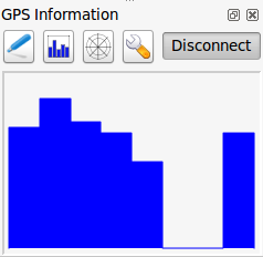
GPS tracking signal strength
Graphe polaire
If you want to know where in the sky all the connected
satellites are, you have to switch to the polar screen. You can also see the
ID numbers of the satellites you are receiving signals from.
Figure GPS polar window:
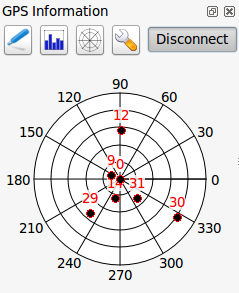
GPS tracking polar window
Configuration GPS
In case of connection problems, you can switch between:
 Autodetect
 Internal
- Serial device
- gpsd (selecting the Host, Port and Device your
GPS is connected to)
Cliquez à nouveau sur [Connecter] pour réinitialiser la connexion avec le récepteur GPS.
Figure GPS Tracking 2:
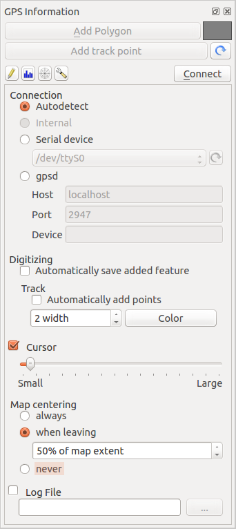
GPS tracking options window
Vous pouvez activer Enregistrer automatiquement chaque entité ajoutée lorsque vous êtes en mode édition. Ou vous pouvez activer Ajouter automatiquement des points en choisissant la largeur et la couleur.
En activant Curseur, utilisez le curseur  pour augmenter ou diminuer la taille du curseur marquant la position du GPS sur la carte.
Activating Map centering allows you to decide in which
way the canvas will be updated. This includes ‘always’, ‘when leaving’, if your
recorded coordinates start to move out of the canvas, or ‘never’, to keep map
extent.
Enfin, vous pouvez activer le Fichier journal et définir un fichier pour enregistrer les messages du suivi GPS.
If you want to set a feature manually, you have to go back to
Position and click on [Add Point] or [Add track point].
Connexion à un GPS Bluetooth pour le suivi en direct
Avec QGIS, vous pouvez vous connecter à une GPS Bluetooth pour la récupération de données terrain. Pour réaliser cette tâhce, voux aurez besoin d’un GPS Bluetooth et d’un récepteur Bluetooth sur votre ordinateur.
Au démarrage, vous devez faire en sorte que votre GPS soit reconnue et appairé avec votre ordinateur. Allumez le GPS, allez dans l’icône Bluetooth de votre barre de notification et rechercher un Nouveau Périphérique.
Sur le côté droit du masque de sélection des périphériques, assurez-vous que tous les périphériques sont sélectionnés pour garantir que votre unité GPS apparaissent dans cette sélection. Dans la prochaine étape, un service de connexion série devrait être disponible. Sélectionnez-le et cliquez sur le bouton [Configurer].
Retenez le numéro du port COM affecté à la connexion GPS dans les propriétés Bluetooth.
After the GPS has been recognized, make the pairing for the connection. Usually the autorization code is 0000.
Now open GPS information panel and switch to GPS
options screen. Select the COM port assigned to the GPS connection and click
the [Connect]. After a while a cursor indicating your position should
appear.
Si QGIS ne peut recevoir de données GPS, vous devriez alors redémarrer votre GPS, attendre 5-10 secondes et réessayer de le connecter. Généralement, celle solution fonctionne. Si vous avez de nouveau une erreur de connexion, assurez-vous que vous n’avez pas un autre capteur Bluetooth à proximité, apparairé avec le GPS.
Utiliser un Garmin GPSMAP 60cs
MS Windows
Le moyen le plus facile pour le faire fonctionner est d’utiliser un logiciel intermédiaire (en freeware mais pas libre) appelé GPSGate.
Launch the program, make it scan for GPS devices (works for both USB and BT
ones) and then in QGIS just click [Connect] in the Live tracking panel
using the Autodetect mode.
Ubuntu/Mint GNU/Linux
Comme pour Windows le plus simple est d’utiliser un serveur intermédiaire, dans ce cas GPSD, donc
sudo apt-get install gpsd
Vous pouvez alors charger le module du noyau garmin_gps
sudo modprobe garmin_gps
Connectez ensuite l’unité. Vérifiez avec dmesg que le périphérique utilisé par l’unité, par exemple /dev/ttyUSB0. Maintenant, vous pouvez lancer qpsd.
gpsd /dev/ttyUSB0
Connectez enfin avec l’outil de suivi en direct de QGIS.
Utiliser BTGP-38KM datalogger (seulement Bluetooth)
Utiliser GPSD (sous GNU/Linux) ou GPSGate (sous Windows) est très facile.
Utiliser BlueMax GPS-4044 datalogger (BT et USB)
MS Windows
The live tracking works for both USB and BT modes, by using GPSGate or even
without it, just use the Autodetect mode, or point
the tool the right port.
Ubuntu/Mint GNU/Linux
Via USB
Le suivi en direct fonctionne avec les deux sous GPSD.
gpsd /dev/ttyACM3
ou sans lui en connectant l’outil de suivi en direct de QGIS directement au périphérique (par exemple /dev/ttyACM3).
Via Bluetooth
Le suivi en direct fonctionne avec les deux sous GPSD.
gpsd /dev/rfcomm0
ou sans lui en connectant l’outil de suivi en direct de QGIS directement au périphérique (par exemple /dev/rfcomm0).