.
Client MetaSearch pour les Services de Catalogage
Introduction
MetaSearch est une extension QGIS permettant d’interagir avec des services de catalogage de données. MetaSearch supporte le standard OGC CSW (Catalogue Service for the Web)
MetaSearch fournit une approche simple et intuitive ainsi qu’une interface conviviale pour la recherche de catalogues de métadonnées depuis QGIS.
Installation
MetaSearch is included by default with QGIS 2.0 and higher. All dependencies are included within MetaSearch.
Installer MetaSearch depuis le gestionnaire d’extensions QGIS, ou manuellement depuis http://plugins.qgis.org/plugins/MetaSearch.
Travailler avec des Catalogues de Métadonnées dans QGIS
CSW (Catalogue Service for the Web)
CSW (Catalogue Service for the Web) is an OGC (Open Geospatial Consortium) specification, that defines common interfaces to discover, browse, and query metadata about data, services, and other potential resources.
Démarrage
To start MetaSearch, click the MetaSearch icon or select Web / MetaSearch / MetaSearch via the QGIS main menu. The MetaSearch dialog will appear. The main GUI consists of two tabs: ‘Services’ and ‘Search’.
Gérer les Services de Catalogage
The ‘Services’ tab allows the user to manage all available catalogue services. MetaSearch provides a default list of Catalogue Services, which can be added by pressing ‘Add default services’ button.
Pour la liste complète des Services de Catalogage, cliquer sur la liste déroulante.
To add a Catalogue Service entry, click the ‘New’ button, and enter a Name for the service, as well as the URL/endpoint. Note that only the base URL is required (not a full GetCapabilities URL). Clicking ok will add the service to the list of entries.
To edit an existing Catalogue Service entry, select the entry you would like to edit and click the ‘Edit’ button, and modify the Name or URL values, then click ok.
To delete a Catalogue Service entry, select the entry you would like to delete and click the ‘Delete’ button. You will be asked to confirm deleting the entry.
MetaSearch allows for loading and saving connections to an XML file. This is useful when you need to share settings between applications. Below is an example of the XML file format.
<?xml version="1.0" encoding="UTF-8"?>
<qgsCSWConnections version="1.0">
    <csw name="Data.gov CSW" url="http://catalog.data.gov/csw-all"/>
    <csw name="Geonorge - National CSW service for Norway" url="http://www.geonorge.no/geonetwork/srv/eng/csw"/>
    <csw name="Geoportale Nazionale - Servizio di ricerca Italiano" url="http://www.pcn.minambiente.it/geoportal/csw"/>
    <csw name="LINZ Data Service" url="http://data.linz.govt.nz/feeds/csw"/>
    <csw name="Nationaal Georegister (Nederland)" url="http://www.nationaalgeoregister.nl/geonetwork/srv/eng/csw"/>
    <csw name="RNDT - Repertorio Nazionale dei Dati Territoriali - Servizio di ricerca" url="http://www.rndt.gov.it/RNDT/CSW"/>
    <csw name="UK Location Catalogue Publishing Service" url="http://csw.data.gov.uk/geonetwork/srv/en/csw"/>
    <csw name="UNEP/GRID-Geneva Metadata Catalog" url="http://metadata.grid.unep.ch:8080/geonetwork/srv/eng/csw"/>
</qgsCSWConnections>
To load a list of entries, click the ‘Load’ button. A new window will appear; click the ‘Browse’ button and navigate to the XML file of entries you wish to load and click ‘Open’. The list of entries will be displayed. Select the entries you wish to add from the list and click ‘Load’.
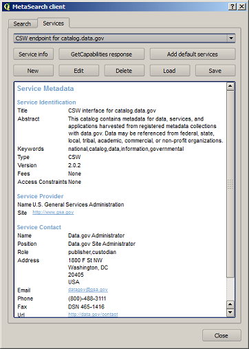
The ‘Service info’ button displays information about the selected Catalogue Service such as service identification, service provider and contact information. If you would like to view the raw XML response, click the ‘GetCapabilities response’ button. A separate window will open displaying Capabilities XML.
Recherche de Services de Catalogage
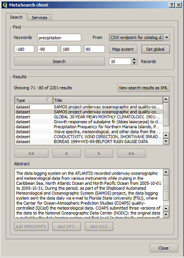
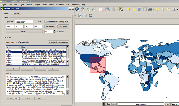
The ‘Search’ tab allows the user to query Catalogue Services for data and services, set various search parameters and view results.
Les paramètres de recherche suivants sont disponibles :
- Keywords: free text search keywords
- From: the Catalogue Service to perform the query against
- Bounding box: the spatial area of interest to filter on. The default bounding box is the map view / canvas. Click ‘Set global’ to do a global search, or enter custom values as desired
- Records: the number of records to return when searching. Default is 10 records
Clicking the ‘Search’ button will search the selected Metadata Catalogue. Search results are displayed in a list and are sortable by clicking on the column title. You can navigate through search results with the directional buttons below the search results. Clicking the ‘View search results as XML’ button opens a window with the service response in raw XML format.
Clicking a result will show the record’s abstract in the ‘Abstract’ window and provides the following options:
si l’élément de métadonnée a une zone géographique associée, l’empreinte de cette zone géographique sera visible sur la carte
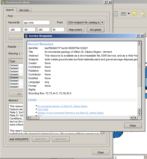
double-cliquer sur l’enregistrement affiche l’élément de métadonnée ainsi que les hyperliens associés. Cliquer sur un lien l’ouvre dans le navigateur internet de l’utilisateur
- if the record is an OGC web service (WMS/WMTS, WFS, WCS), the appropriate ‘Add to WMS/WMTS|WFS|WCS’ buttons will be enabled for the user to add to QGIS. When clicking this button, MetaSearch will verify if this is a valid OWS. The OWS will then be added to the appropriate QGIS connection list, and the appropriate WMS/WMTS|WFS|WCS connection dialogue will then appear
Paramètres
You can fine tune MetaSearch with the following settings:
- Connection naming: when adding an OWS connection (WMS/WMTS|WFS|WCS), the connection is stored with the various QGIS layer provider. Use this setting to set whether to use the name provided from MetaSearch, whether to overwrite or to use a temporary name
- Results paging: when searching metadata catalogues, the number of results to show per page
- Timeout: when searching metadata catalogues, the number of seconds for blocking connection attempt. Default value is 10