.
Морфометрический анализ
 The Raster Terrain Analysis Plugin can be used to calculate the
slope, aspect, hillshade, ruggedness index and relief for digital elevation
models (DEM). It is very simple to handle and provides an intuitive graphical
user interface for creating new raster layers (see Figure_raster_terrain_1).
The Raster Terrain Analysis Plugin can be used to calculate the
slope, aspect, hillshade, ruggedness index and relief for digital elevation
models (DEM). It is very simple to handle and provides an intuitive graphical
user interface for creating new raster layers (see Figure_raster_terrain_1).
Виды анализа:
- Slope: Calculates the slope angle for each cell in degrees (based on first- order derivative estimation).
Экспозиция: Экспозиция (начиная с 0 градусов на север, против часовой стрелки).
- Hillshade: Creates a shaded map using light and shadow to provide a more three-dimensional appearance for a shaded relief map.
- Ruggedness Index: A quantitative measurement of terrain heterogeneity as described by Riley et al. (1999). It is calculated for every location by summarizing the change in elevation within the 3x3 pixel grid.
- Relief: Creates a shaded relief map from digital elevation data. Implemented is a method to choose the elevation colors by analysing the frequency distribution.
Figure Raster Terrain 1:
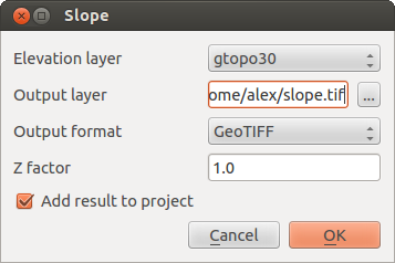
Модуль морфометрического анализа (расчет угла уклонов)
Использование модуля
Запустите QGIS и загрузите растр цифровой модели рельефа
gtopo30из демонстрационного набора данных GRASS.- Load the Raster Terrain Analysis plugin in the Plugin Manager (see The Plugins Dialog).
- Select an analysis method from the menu (e.g., Raster ‣ Terrain Analysis ‣ Slope). The Slope dialog appears as shown in Figure_raster_terrain_1.
Укажите выходной файл и его формат.
Нажмите [OK].