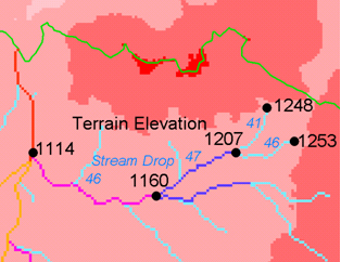
Stream Drop Analysis
Description
Applies a series of thresholds (determined from the input parameters) to the input accumulated stream source grid (*ssa) grid and outputs the results in the *drp.txt file the stream drop statistics table. This function is designed to aid in the determination of a geomorphologically objective threshold to be used to delineate streams. Drop Analysis attempts to select the right threshold automatically by evaluating a stream network for a range of thresholds and examining the constant drop property of the resulting Strahler streams. Basically it asks the question: Is the mean stream drop for first order streams statistically different from the mean stream drop for higher order streams, using a T-test. Stream drop is the difference in elevation from the beginning to the end of a stream defined as the sequence of links of the same stream order. If the T-test shows a significant difference then the stream network does not obey this “law” so a larger threshold needs to be chosen. The smallest threshold for which the T-test does not show a significant difference gives the highest resolution stream network that obeys the constant stream drop “law” from geomorphology, and is the threshold chosen for the “objective” or automatic mapping of streams from the DEM. This function can be used in the development of stream network rasters, where the exact watershed characteristic(s) that were accumulated in the accumulated stream source grid vary based on the method being used to determine the stream network raster.
The constant stream drop “law” was identified by Broscoe (1959). For the science behind using this to determine a stream delineation threshold, see Tarboton et al. (1991, 1992), Tarboton and Ames (2001).
Parameters
- D8 Contributing Area Grid [raster]
- A grid of contributing area values for each cell that were calculated using the D8 algorithm. The contributing area for a cell is the sum of its own contribution plus the contribution from all upslope neighbors that drain to it, measured as a number of cells or the sum of weight loadings. This grid can be obtained as the output of the “D8 Contributing Area” tool. This grid is used in the evaluation of drainage density reported in the stream drop table.
- D8 Flow Direction Grid [raster]
- A grid of D8 flow directions which are defined, for each cell, as the direction of the one of its eight adjacent or diagonal neighbors with the steepest downward slope. This grid can be obtained as the output of the “D8 Flow Directions” tool.
- Pit Filled Elevation Grid [raster]
- A grid of elevation values. This is usually the output of the “Pit Remove” tool, in which case it is elevations with pits removed.
- Accumulated Stream Source Grid [raster]
- This grid must be monotonically increasing along the downslope D8 flow directions. It it compared to a series of thresholds to determine the beginning of the streams. It is often generated by accumulating some characteristic or combination of characteristics of the watershed with the “D8 Contributing Area” tool, or using the maximum option of the “D8 Flow Path Extreme” tool. The exact method varies depending on the algorithm being used.
- Outlets Shapefile [vector: point]
- A point shapefile defining the outlets upstream of which drop analysis is performed.
- Minimum Threshold [number]
This parameter is the lowest end of the range searched for possible threshold values using drop analysis. This technique looks for the smallest threshold in the range where the absolute value of the t-statistic is less than 2. For the science behind the drop analysis see Tarboton et al. (1991, 1992), Tarboton and Ames (2001).
Default: 5
- Maximum Threshold [number]
This parameter is the highest end of the range searched for possible threshold values using drop analysis. This technique looks for the smallest threshold in the range where the absolute value of the t-statistic is less than 2. For the science behind the drop analysis see Tarboton et al. (1991, 1992), Tarboton and Ames (2001).
Default: 500
- Number of Threshold Values [number]
The parameter is the number of steps to divide the search range into when looking for possible threshold values using drop analysis. This technique looks for the smallest threshold in the range where the absolute value of the t-statistic is less than 2. For the science behind the drop analysis see Tarboton et al. (1991, 1992), Tarboton and Ames (2001).
Default: 10
- Spacing for Threshold Values [selection]
This parameter indicates whether logarithmic or linear spacing should be used when looking for possible threshold values using drop ananlysis.
Options:
- 0 — Logarithmic
- 1 — Linear
Default: 0
Outputs
- D-Infinity Drop to Stream Grid [file]
This is a comma delimited text file with the following header line:
- ::
- Threshold,DrainDen,NoFirstOrd,NoHighOrd,MeanDFirstOrd,MeanDHighOrd,StdDevFirstOrd,StdDevHighOrd,T
The file then contains one line of data for each threshold value examined, and then a summary line that indicates the optimum threshold value. This technique looks for the smallest threshold in the range where the absolute value of the t-statistic is less than 2. For the science behind the drop analysis, see Tarboton et al. (1991, 1992), Tarboton and Ames (2001).
Console usage
processing.runalg('taudem:streamdropanalysis', d8_contrib_area_grid, d8_flow_dir_grid, pit_filled_grid, accum_stream_source_grid, outlets_shape, min_treshold, max_threshold, treshold_num, step_type, drop_analysis_file)
See also
- Broscoe, A. J., (1959), “Quantitative analysis of longitudinal stream profiles of small watersheds”, Office of Naval Research, Project NR 389-042, Technical Report No. 18, Department of Geology, Columbia University, New York.
- Tarboton, D. G., R. L. Bras and I. Rodriguez-Iturbe, (1991), “On the Extraction of Channel Networks from Digital Elevation Data”, Hydrologic Processes, 5(1): 81-100.
- Tarboton, D. G., R. L. Bras and I. Rodriguez-Iturbe, (1992), “A Physical Basis for Drainage Density”, Geomorphology, 5(1/2): 59-76.
- Tarboton, D. G. and D. P. Ames, (2001), “Advances in the mapping of flow networks from digital elevation data”, World Water and Environmental Resources Congress, Orlando, Florida, May 20-24, ASCE, http://www.engineering.usu.edu/dtarb/asce2001.pdf.