D-Infinity Reverse Accumulation
Description
This works in a similar way to evaluation of weighted Contributing area, except that the accumulation is by propagating the weight loadings upslope along the reverse of the flow directions to accumulate the quantity of weight loading downslope from each grid cell. The function also reports the maximum value of the weight loading downslope from each grid cell in the Maximum Downslope grid.
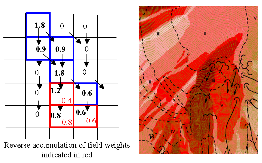
This function is designed to evaluate and map the hazard due to activities that may have an effect downslope. The example is land management activities that increase runoff. Runoff is sometimes a trigger for landslides or debris flows, so the weight grid here could be taken as a terrain stability map. Then the reverse accumulation provides a measure of the amount of unstable terrain downslope from each grid cell, as an indicator of the danger of activities that may increase runoff, even though there may be no potential for any local impact.
Parameters
- D-Infinity Flow Direction Grid [raster]
- A grid giving flow direction by the D-infinity method. Flow direction is measured in radians, counter clockwise from east. This can be created by the tool “D-Infinity Flow Directions”.
- Weight Grid [raster]
- A grid giving weights (loadings) to be used in the accumulation.
Outputs
- Reverse Accumulation Grid [raster]
- The grid giving the result of the “Reverse Accumulation” function. This works in a similar way to evaluation of weighted Contributing area, except that the accumulation is by propagating the weight loadings upslope along the reverse of the flow directions to accumulate the quantity of loading downslope from each grid cell.
- Maximum Downslope Grid [raster]
- The grid giving the maximum of the weight loading grid downslope from each grid cell.
Console usage
processing.runalg('taudem:dinfinityreverseaccumulation', -ang, -wg, -racc, -dmax)