D-Infinity Flow Directions
Description
Assigns a flow direction based on the D-infinity flow method using the steepest slope of a triangular facet (Tarboton, 1997, “A New Method for the Determination of Flow Directions and Contributing Areas in Grid Digital Elevation Models”, Water Resources Research, 33(2): 309-319). Flow direction is defined as steepest downward slope on planar triangular facets on a block centered grid. Flow direction is encoded as an angle in radians counter-clockwise from east as a continuous (floating point) quantity between 0 and 2π. The flow direction angle is determined as the direction of the steepest downward slope on the eight triangular facets formed in a 3 x 3 grid cell window centered on the grid cell of interest. The resulting flow in a grid is then usually interpreted as being proportioned between the two neighboring cells that define the triangular facet with the steepest downward slope.
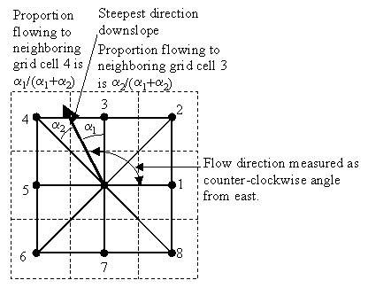
A block-centered representation is used with each elevation value taken to represent the elevation of the center of the corresponding grid cell. Eight planar triangular facets are formed between each grid cell and its eight neighbors. Each of these has a downslope vector which when drawn outwards from the center may be at an angle that lies within or outside the 45 degree (π/4 radian) angle range of the facet at the center point. If the slope vector angle is within the facet angle, it represents the steepest flow direction on that facet. If the slope vector angle is outside a facet, the steepest flow direction associated with that facet is taken along the steepest edge. The slope and flow direction associated with the grid cell is taken as the magnitude and direction of the steepest downslope vector from all eight facets. Slope is measured as drop/distance, i.e. tan of the slope angle.
In the case where no slope vectors are positive (downslope), the flow direction is set using the method of Garbrecht and Martz (1997) for the determination of flow across flat areas. This makes flat areas drain away from high ground and towards low ground. The flow path grid to enforce drainage along existing streams is an optional input, and if used, takes precedence over elevations for the setting of flow directions.
The D-infinity flow direction algorithm may be applied to a DEM that has not had its pits filled, but it will then result in “no data” values for the D-infinity flow direction and slope associated with the lowest point of the pit.
Parameters
- Pit Filled Elevation Grid [raster]
- A grid of elevation values. This is usually the output of the “Pit Remove” tool, in which case it is elevations with pits removed.
Outputs
- D-Infinity Flow Directions Grid [raster]
- A grid of flow directions based on the D-infinity flow method using the steepest slope of a triangular facet. Flow direction is determined as the direction of the steepest downward slope on the 8 triangular facets of a 3x3 block centered grid. Flow direction is encoded as an angle in radians, counter-clockwise from east as a continuous (floating point) quantity between 0 and 2π. The resulting flow in a grid is then usually interpreted as being proportioned between the two neighboring cells that define the triangular facet with the steepest downward slope.
- D-Infinity Slope Grid [raster]
- A grid of slope evaluated using the D-infinity method described in Tarboton, D. G., (1997), “A New Method for the Determination of Flow Directions and Contributing Areas in Grid Digital Elevation Models”, Water Resources Research, 33(2): 309-319. This is the steepest outwards slope on one of eight triangular facets centered at each grid cell, measured as drop/distance, i.e. tan of the slope angle.
Console usage
processing.runalg('taudem:dinfinityflowdirections', -fel, -ang, -slp)